Koutous Gr
Type Locality and Naming
The word “Koutous” means “Today, we rest”. Faure (1966) describes several sections. Among these, he states that “under the upper plateau of “Mont Maré” (south of Tchocoda), which includes 3 m of altered and ironized argillaceous sandstones, can be observed the typical succession of the “grès du Koutous”. The lithological package which constitutes the Koutous Group corresponds, depending on the locality, to ages that are undoubtedly variable but with undistinguishable facies. Therefore, the name "Koutous Group" seems to be justified.
References: Faure, 1966; Greigert, 1966; Bernus et al., 1980; Fabre et al., 1983; Karimoune, 1994.
Synonym: Grès du Koutous. Equivalent(s): The lower levels are, arguably, a crude lateral equivalent of the Farak Fm; the middle part could be continental Cenomanian-Turonian, and the higher levels of Koutous could include Senonian, even the extreme base of the Cenozoic. See also comments under “ Totomaye Fm ”
Lithology and Thickness
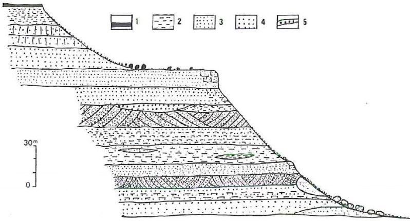
These sandstones, essentially made of coarse elements, have siliceous and kaolinic constituent material. There are white, pink and purple colors. The sections include quartz-pebble levels, clay-cement feldspathic sandstones, compact fine sandstones and violet shale lenses. Cross-stratified structures and lateral facies variations are common (Fig. 1). Faure (1966) describes its petrographic character as follows:
- The abundance of heterogeneous detrital rocks poorly sorted with irregular grains.
- The presence of massive silty or shaly-silt layers.
- The double origin of the argillaceous phase seems to be either detrital or comes from the later alteration of minerals themselves detrital.
- The scarcity of feldspars and unaltered micas, but their frequent presence in the original sediment is attested by residual ghosts.
- The total absence of limestone and, it seems, of montmorillonite.
- An iron content is close to normal (approximately 3 to 5%). We note the absence of ferruginous levels or platelets, very frequent at Termit, Agadem and Kafra.
- The scarcity of silicified plant remains and the total absence of other fossils.
Variable thickness depending on whether one is located in the outcrop zone of the Precambrian or further north, in the plateau region. This thickness is between 0 and 400 m. The total thickness is never reached anywhere, either by the gap in the lower parts or because of the erosion of the upper parts.
[Figure 1. Section of the Koutous Gr on the “Plateau du Koutous” in Mahiram. 1) upper lateritic cuirass: 2) shaly sandstone: 3) fine sandstone; 4) coarse sandstone; 5) quartz pebble level (Source: Karimoune, 1994). ]
Relationships and Distribution
Lower contact
Precambrian is below
Upper contact
Erosional upper surface corresponding to today’s topography or the mid-quaternary. In some areas, blocs of large ferrugineous oolithes (Zaouzaoua Fm) are preserved at the top of the Group.
Regional extent
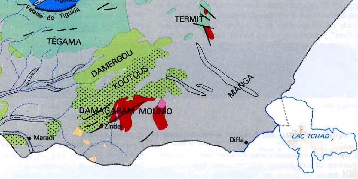
The area the group occupies (Fig. 2) stretches for 200 km in the E-W direction, north of Damagaram and Mounio. It continues north to the southern limit of marine fauna formations. Therefore, in the N-S direction, its width varies from a few tens to less than one hundred kilometers.
[Figure 2. The Koutous Gr outcropping north of Zinder and the Damagaram Mounio (Bernus et al., 1980).]
GeoJSON
Fossils
Rare silicified wood
Age
Depositional setting
Considering its lithological characteristics, Faure concludes with a terrigenic origin of the Koutous Group. It was deposited in a continental environment by rivers with violent and irregular currents. In addition, the sediments have undergone alteration after their deposition. Therefore, these facies are pretty comparable to the type usually called "siderolithic", although their iron content is low.
Additional Information

